PNW Outdoor Planner
Plugin (2026)A Claude Code plugin for planning backcountry trips in Washington, Oregon, Idaho, and the British Columbia.
Overview
Planning a mountain trip requires quite a fair amount of data wrangling. Living in the Pacific Northwest, a two-day ski tour on Mt. Baker, for example, touches any number of NWS point forecast and the forecaster's discussion, trailhead access, SNOTEL data, NWAC observations, Forest Service alerts, WSDOT road/pass conditions, trip reports (information and conditions), and sunrise and sunset. Each piece of data adds different factors to a Go/No-Go verdict that is catastrophic in the true-negative (you go and something bad or unexpected happens) case.
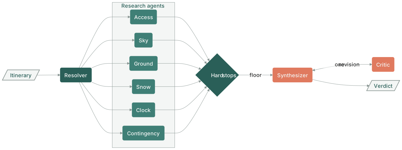
I built a Claude Code plugin that answers that question for backcountry travel in Washington, Oregon, Idaho, and the British Columbia fringe. It takes an itinerary with a coordinate for every day, resolves each day to the sources that govern it, sends six research agents to read them, and returns one report containing the verdict, the reasoning chain under it, and what would flip it. Recently, I added to the report optional morning-of check, timing, contingency plans, a self-curated list of interactive maps, and route GPX files for Gaia or CalTopo.
How it works
- First, bundle each day of a trip's trailhead and high point, finds the state, NWS office and grid cell, avalanche zone (for winter trips), land units that contain the trail, nearest SNOTEL stations, river gauges, and webcams by distance. Each bundle contains forecast URLs, the permit systems in window, the sun times, and the curated filled in map links.
- Using the bundle as context, run six agents in parallel, each owning a key decision factor:
- Access reads roads, gates, permits, and fire.
- Sky reads the forecast, the discussion, alerts, and smoke.
- Ground reads trail conditions, crossings, glacier state, and trip reports.
- Snow reads avalanche products and telemetry and lays the problem types over the route's own slope angles and aspects.
- Clock computes pace, daylight, and turnaround from the route stats.
- Contingency covers bailouts, coverage, and search and rescue.
- An Opus agent synthesizes the 6 reports using a seven-step protocol that weighs the reports together, taking into account strict No-Go use cases. It provides a Go/No-Go verdict that a critic then checks to ensure sound reasoning, sending back for at most one revision.
51
catalog sources8
agents~10 min
runtime
Design decisions
- The workflow script has no clock and no filesystem. Today's date and the plugin root arrive as arguments, so a run is reproducible from its inputs and the same itinerary can be re-run a week later against the same code.
- Sonnet reads, Opus judges. divvying up trip planning into its atomic factors allows smaller models to focus on smaller tasks. This enforces a cleaner no-go verdict by the synthesizer, which uses a strong model for the important inference. The adversarial critic is just as important, ensuring that irreversible hazards are taken into account in a never-fail scenario. This dramatically improved the quality of contingency plans in contested evals.
- The source catalog is a loose contract. Common sources (weather.gov, NWAC, etc) are important to use, but not always the full picture. For example, a run on Mt. Baker added regional road news and USGS 3DEP slope sampling.
- Aggressively validate information Permit windows change year-to-year, using a March 2025 trip report in March 2026 is catastrophic, so we tag any source as unverified until proven otherwise.
Install
From claude.ai/Cowork: Settings Plugins search 'tannerorourke' Add
From CLI:
claude plugin marketplace add tannerorourke/pnw-outdoor-planner
claude plugin install pnw-outdoor-planner@pnw-outdoor-planner
Then /pnw-outdoor-planner:plan with a description of the trip. Intake pins down the dates and daily coordinates, shows the bundles before research spends tokens, and lastly adds the report plus a GPX of the route in a cache folder for Gaia or CalTopo.